|
|||||||||||||||||||||||||||||||||||||||||||||||||||||||||||||||||||||||||||||||||||||||||||||||||||||||||||||||||||||||||||||||||||||||||||||||||||||||||||||||||||||||||||||||||||||||||||||||||||||||||||||||||||||||||||||
| Adapted transcription of Archaelogical Investigation Report by Richard S Jones for Cambrian Archaeological Projects Ltd, 2003 |
|||||||||||||||||||||||||||||||||||||||||||||||||||||||||||||||||||||||||||||||||||||||||||||||||||||||||||||||||||||||||||||||||||||||||||||||||||||||||||||||||||||||||||||||||||||||||||||||||||||||||||||||||||||||||||||
|
|||||||||||||||||||||||||||||||||||||||||||||||||||||||||||||||||||||||||||||||||||||||||||||||||||||||||||||||||||||||||||||||||||||||||||||||||||||||||||||||||||||||||||||||||||||||||||||||||||||||||||||||||||||||||||||
 |
|||||||||||||||||||||||||||||||||||||||||||||||||||||||||||||||||||||||||||||||||||||||||||||||||||||||||||||||||||||||||||||||||||||||||||||||||||||||||||||||||||||||||||||||||||||||||||||||||||||||||||||||||||||||||||||
IntroductionThe Burton Wold Wind Farm proposal is being put forward by Anglian Windpower, part of the Your Energy Ltd group. The proposed site was selected in line with Anglian Windpower’s site selection philosophy to avoid nationally designated landscapes, and local designations, where possible. The most suitable site for the proposal was to the south of Kettering, just east of Burton Latimer, at Burton Wold (proposed area centred on OS NGR: SP49182744). This section of the report details the results of the archaeological assessment of the proposed Burton Wold Wind Farm area with respect to the project’s development and the establishment of issues relevant to Environmental Impact Assessment. Cambrian Archaeological Projects Ltd were contracted by Dulas Ltd to carry out the archaeological assessment of the proposed area. Both the desk-based study and the field study took place between 17th- 21st February 2003. Scope and Objectives of the StudyThe main scope and objectives of the archaeological assessment were to reveal by desk-based study, the nature, significance and, where possible, the chronology of the archaeology within the area of the proposed development. The purpose of the desk-based assessment, in accordance with standards and guidance as laid down by the Institute of Field Archaeology, is to gain information about the known or potential archaeological resource within the given area (including presence or absence, character and extent, date, integrity, state of preservation and relative quality of the potential archaeological resource), in order to make an assessment of its merit in context, leading to one or more of the following:
With regards to the field survey the main objective in accordance with the standards and guidance laid down by the Institute of Field Archaeology is to gain information about the archaeological resource within a given area or site (including presence or absence, character, extent, date, integrity, state of preservation and quality), in order to make an assessment of its merit in the appropriate context, leading to one or more of the following:
The field study aimed to examine on the ground the land designated for the proposed wind farm, and isolate and record any archaeology and historic landscape features that survive within it. All gathered material from the desk-based study and the field study were to be combined and assessed, in order to identify areas where the proposed development may impact on the recognised archaeology or elements of the historic landscape, and depending on the results of the study, any potential mitigating circumstances that may arise. MethodologyFor the purposes of the archaeological desk based study the following repositories were consulted:
At both of these repositories all Ordnance Survey 1st and 2nd edition maps were consulted along with earlier Enclosure Award maps. The desk-based study also consulted the Victoria County History of Northamptonshire and the Royal Commission’s (RCAHM) County History. For the purposes of the Field Study once all cartographic and archaeological records had been consulted and all relevant material identified, the whole of the proposed area was then field walked. A finds sampling strategy was in place during the field study should any surface scatters of pottery shards or other potential finds warrant it. The assessment methods used follow those detailed in the Design Manual for Roads and Bridges (DMRB, Volume 11, Section 3, part 2) and the CADW Guidelines and Methodology for assessing significance of impacts of development on historic landscape areas on the register of landscapes of historical interest in Wales (Second draft 15-09-2000) All sites identified have been categorised following guidelines set out in the DMRB. The allocation of a site to a category defines the archaeological significance and class of that site or monument. The categories are described as follows:
The following provides an indication as to the predicted impact the proposed development will have on individual archaeological features. The scale of the impact needs to be viewed in conjunction with the class of the monument, in order to appreciate the overall significance the development will have on a given archaeological feature. There are five levels of Impact severity (Cadw 2000).
Reference Sources for the Study The main historic documentary sources consulted were the Victorian County History of Northamptonshire, Vols 1, 2, 3. Cartographic sources included the Inclosure map of Burton Latimer dated 1803, the OS 1st edition 6 inch to 1 mile map dated 1887, the OS 2nd edition 6 inch to 1 mile map dated 1901, and the late revised OS edition map dated 1927. In terms of archaeology the main sources consulted were the Sites and Monuments Record at Northampton County Council and the Royal Commissions Inventory of Northamptonshire Vols 1979. The name Harpur is marked on the 1803 map as Joseph Harpur who owned the large field south west of the survey area (area of turbine no’s 2, 5 and 8). On the later OS 2nd edition map of 1901 the name Harpur appears again as the name of the former Lodge house that was located at the southern end of the survey area, known as ‘Harpur’s Lodge’, now demolished with little surface remains (ID No: 116). On the Inclosure map of 1804 a large portion of the survey area to the north is marked down as Rectory land. Within the VCHN there is mention of this land: “A considerable amount of land was attached to the rectory and in 1330 the rector was said to hold two carucates. He and his predecessors held a view of frank-pledge, waifs and strays, the assize of bread and beer, and certain amercements. The right to hold the view was disputed by the crown officials, but the rector recovered it on payment of a fine.” (Page 185 VCHN Vol 3)
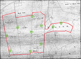
Later in history at the time of the Inclosures a fair bit of land was donated to the Church. Further still more land was donated to the church as allotments for the Poor. “An allotment of 10 acres was set out on an inclosure of the lands in this parish in 1804 in lieu of land formerly appropriated to the repairs of the church. This land was sold in 1919 and the proceeds invested in £517 10s. 7d. 5 per cent. War Stock, producing £25 17s.6d. yearly in dividends. The income is applied by the churchwardens towards church repairs.” (p185 VCHN Vol3) “Another allotment containing about 2.75 acres was set out in lieu of land formerly called the Bell Land or Bell Close. This land was also sold in 1919 and the proceeds invested in £171-16s.1d. 5 per cent. War Stock, producing £8 11s. 10d. yearly in dividends. This is also applied by the churchwardens towards church repairs.” (p185-186 VCHN Vol3)The land once known as Bell Land or Bell Close is likely that marked on the Inclosure Map of 1803, but here it is marked as ‘Bell Acre’ (No: 66 on 1803 Inclosure map). This land is immediately below the land marked as Church Land (No: 65 on 1803 Inclosure map - Id No: 110 on site map). Other examples of donated land are: “By his will, date unknown, Richard Hopkins gave a piece of land in Burton Latimer containing about I a. 3 r. to the churchwardens for the poor. The land has been sold and the endowment now consists of £246 7s. 8d. Consols producing £6 3s. yearly, which is applied in the distribution of six 2lb. loaves weekly to the poor.” (p186 VCHN Vol3) “An allotment of 70 acres was awarded for the benefit of the poor upon the inclosure of the parish. The charity is administered by the lord of the manors of Burton Latimer, the rector of St. Mary and 4 other trustees in compliance with a scheme of the Charity Commissioners dated 23 May 1919. The land was sold for £2,500 in 1919. Owing to the insolvency of the solicitor acting for the trustees the deposit money of £250 was lost. The residue of £2,250 was invested in £2,812 10s. 4 per cent. Funding Stock.” (p186 VCHN Vol3). Inclosure Award Map of 1803/4
To the north, in the area of proposed turbine no’s 6 and 7, this land was the property of the church, it was Rectory Land likely laid out for agriculture. This area adjoined the field known as Braken and Boshill Field, further to the north west. No structures are evident on the 1803 map in this area. South of here however the land appears to have been the property of several occupiers at this time; William King Esq occupied the field next door to the present Burton Wold Farm; above King’s land was the field occupied by John Robinson; the Reverend William Bosbury occupied the field to the south west ; the field in the centre of the proposed area was occupied by one Joseph Harpur, as already mentioned within the historic section; the three fields immediately north of Harpur’s field appear to have been divided into three portions, the first and the largest was laid out as common land for the Burton Latimer Poor. Next to this field to the east was an area owned by the Church, called Church Land. Within this field there appears to have been a sub field known as ‘Bell acre’ (id No: 110). What the function of this field was at this time is uncertain. This field has already been mentioned in the historic section. No structures are marked within any of the fields of the 1803 Inclosure map. [Website Note: For a discussion of the Inclosure of Burton Latimer, and to see a copy of the map, click here] OS 1st Edition 1884 map
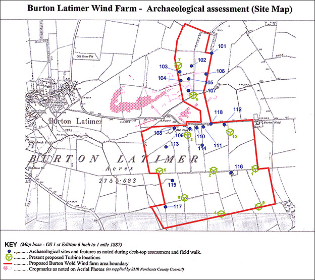
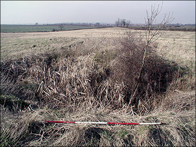
A further small roofed structure (Id No: 117) is located in the corner of the former ‘Reverend William Bosburys’ field by a former track-way (NGR SP 9145 7406). The only other features noted within the survey area on the OS 1st edition map of 1884 are a former stone pit (Id No: 108) located within the former Burton Latimer Poor Allotment field (NGR SP 9150 7477). A series of three tracks lead to and from this pit. The last feature is a small pond (Id 108) located in the former Joseph Harpur’s Field of 1803 (NGR SP 9150 7430). Apart from these few structures and features evident on the OS 1st edition map of 1884 the only other features of significance are a handful of former field boundaries, no longer present, to the north, in the area of turbines 6 and 7. At this time the field boundary separating the former ‘Church Land’ and ‘Bell Acres’ (Id No’s: 109/110) appear to be still present. OS 2nd Edition 1901 mapThe OS 2nd Edition map was published very soon after the 1st edition 1884 map. As such very little appears to have changed over such a short space of time, apart from the fact that the former stone pit (Id No: 108) now appears to have become disused and is slowly disappearing. The former Lodge (Id No: 116) has now been marked on this edition map as ‘Harpur’s Lodge’.
The area once known as the Burton Latimer Poor Allotments in 1804, is now marked again as Allotments. In the area of the ‘Church Land’ and ‘Bell Acre’ (Id No’s: 109/110) a small structure has now appeared, this is unroofed however and likely was a small shed. In the corner of the field by the former ‘Bell Acre’ the 1927 map has a water well marked on the map to the east (Id No: 111) (NGR SP 9176 7479). What appears to be a very small enclosure is also marked in this area between the well and the small settlement to the east (Id No: 118). No new features are apparent on the 1927 map in the northern point of the proposed survey area. Aerial Photographs Within the proposed survey area there are two main areas of archaeological significance highlighted by the presence of crop-marks on aerial photographs of the area. The first of these is located in the southern portion of the survey area, centred on SP 914746 (Id No: 113). Here RAF photos of 1925 indicate the presence of medieval Ridge-and-furrow. These appear to be arranged in end-on and interlocked furlongs many of markedly reversed-S form. In this field many of these Ridge-and-furrows are still visible as low ridges running east-west (RAF VAP CPE/UK/1925, 1238-47, 2344-52, in RCAHM 1979 p 15 [11]). The other area is located in the northern part of the survey area. Within the area of proposed turbines 6 and 7 aerial photographs of 1995 and 1996 show a series of crop-marks (Id No’s: 102 / 103 / 104 / 105 / 106 / 107), which appear to indicate a small enclosed complex of some description. Within the SMR each these features have been recorded as one complex (SMR No: 5319).
The Aerial Photographs indicate further the presence of earlier field boundaries cutting across the present field to the north and east-west. These earlier field boundaries are marked on the OS 1st and 2nd edition maps. None of the crop-marks visible on the aerial photos are visible on the ground having been repetitively ploughed out over time. Field SurveyThe total area of the proposed wind farm is approx. 1.2 square km. At the time of the field visit virtually the whole of the proposed development area had been recently ploughed with planted crops, except for the fields to the west, in the areas of Id no’s 108, 113, 115 and 117. In terms of archaeological sites and features revealed from the desk-top assessment, Id No’s 101-107, there are no surface traces. Shards of pottery were recovered from the ploughed surface in this area during the field walk, but all of these were post medieval in date, c. 18th/19th centuries. The following refers to id No’s 108 - 118
Other than these features recorded from the early maps and aerial photos, no further archaeological features were noted during the field visit.
From the results of the desk-top assessment and the accompanying field survey of the proposed area, the most significant features in terms of archaeology are those recorded from the 1995/96 aerial photographs in the northern part of the proposed area, in the area of proposed turbines 6 and 7 (Id No’s: 102-107). The Aerial photographs appear to show crop-marks indicative of a possible early enclosed settlement complex with accompanying smaller rectangular/polygonal and curvilinear enclosures circling the main complex to the north, east and south. The main part of this complex is located adjacent to the small stream that runs east to west on the northern bank. As no features are marked on the earliest Enclosure Map of 1803, it is very likely that these crop marks delineate a site that pre-dates this time. The field walk did recover a few shards of pottery from this area on the surface, all mid to late post medieval in date. Immediately west of the survey area the SMR has recorded the presence of a post medieval quarry (magenta hachured area on main site map). Whether the crop-marks predate this post medieval quarry is uncertain without further investigation of this area. So at this time the date of these crop-marks must remain unknown. Category E.Within the same field to the north the OS map of 1901/1927 indicates the presence of a small field enclosure of some description (Id No: 101). This may well be a field gate, otherwise its function is unknown. Category D. Other areas within the survey area of significance are those in the area of the former Church Land and Bell Acre fields (Id No’s: 114 / 109 / 110 / 111). What the purpose of these fields was at this time is uncertain. They may have merely been laid out as areas for planting crops, but this is uncertain. There may well be other reasons behind why this area was so named. Post medieval pottery shards? were recovered from this area. Category E.Immediately east of these two fields the OS 1st and 2nd edition maps revealed the presence of a former post medieval roofed structure and a small enclosure (Id No’s: 112 / 118). The field walk revealed that these structures have since disappeared and any possible surface features have been ploughed out. Surface scatters revealed post medieval demolition debris and pottery shards scattered throughout this area of the field. The main roofed structure is of archaeological significance in terms of an understanding of the development of the area during the post medieval period. Foundation remains of this former structure very likely still exist below the surface. Category D. Of archaeological significance in terms of an understanding of local and regional agricultural practices, is the area to the west within the survey area, the area of former medieval Ridge-and-furrow and old stone pit (Id No’s: 108 / 113). Aerial photos have shown evidence of the remains of Ridge-and-furrow in this field. The field walkover has also confirmed their existence, although in a poor state of preservation. Low ridges are just still visible in areas however. On the OS 1st edition map of 1884 the stone pit in this field is marked down as ‘Old Stone Pit’ indicating that the pit pre-dates 1884, and therefore may be contemporary with the enclosure period in 1804, although it may still be earlier and associated with the medieval Ridge-and-furrow. This is uncertain, however, without further investigation. Category B.The OS maps of 1884 and 1901 show in the central area of the proposed assessment area the existence of a former lodge house, called on the OS 1901 map ‘Harpur’s Lodge’ (Id No: 116). From the Victorian County History of Northamptonshire and the 1803 Inclosure map, the Harpur family appears to have been a fairly prominent family within the area of Burton Latimer throughout the late 18th and early 19th centuries. Today there are no surface features to indicate the presence of this small house/farm complex, apart from the surface scatters of red brick, mortar and occasional 19th and 20th century pottery shards. Again the presence of this former lodge house and farm is significant in terms of an understanding of the development of the local landscape during the 18th and 19th centuries. Category D. To the west the OS maps have shown the former existence of a small roofed structure (Id No: 117) with a former access track. Today there is no real trace of this structure on the surface apart from low banks and traces of demolition debris. Again the presence of this structure is significant in terms of an understanding of the development or evolution of the local landscape during the 18th and 19th centuries. Category E.The former pond (Id No: 115) as marked on the 1st and 2nd edition OS maps to the west within the proposed assessment area is today becoming vegetation filled but is still waterlogged. This pond appears to have once been a small spring but perhaps at some time in the medieval period was dug out or enlarged, and may well be contemporary in date to the medieval Ridge-and-furrow to the north. Category E.
Apart from these sites and features revealed from the desk-top assessment and field survey no further features were observed within the assessment area that were of archaeological significance. Predicted Impacts of the Proposal on known Archaeology
Summary Table of Sites and Features, Category of site and Impact of development on site
Although the present location of turbine no’s 6 and 7, as marked on the site plan, would likely have only a low to fairly severe impact on the present archaeological record (Id No’s: 102– 107), as they located away from the core of the known archaeological features, the full nature, extent and significance of these features is unknown at this stage. Because of this reason and in view of any future development proposals for further turbines in this area, then any ground work would likely have a Very Severe impact which would result in the loss or removal of archaeological evidence. With regards Id No’s: 109 / 110, the areas of ‘Church Land’ and ‘Bell Acres’, the impact on these sites must remain Unknown as the only evidence we have archaeologically is that of place-name evidence. Although the field has been ploughed repetitively over a course of decades, during the field walk there were no visible traces of any pottery shards any earlier than the late post medieval (19th century). However this does not by any means indicate that there is no significant archaeology present in these areas beneath the surface. With regards Id No: 113 the groundwork for the proposal would have a Moderately Severe Impact on the remains of the Ridge-and-furrow. At the time of the field visit however there is very little now visible, only very low ridges and furrows, most of them having been ploughed out. The groundwork for the turbines within the areas that contain Id No’s 108 / 111 / 112 / 115 / 116 / 117 / 118 would likely also only have a Low Impact on these sites as the majority of them are 19th century in date and have either been already demolished or else are quarrying activity and water sources now fallen into disuse. Any groundwork that took place within close proximity to Id No’s: 101 and 114 would have no real Impact as these features were of minor significance and have since disappeared.
|
|||||||||||||||||||||||||||||||||||||||||||||||||||||||||||||||||||||||||||||||||||||||||||||||||||||||||||||||||||||||||||||||||||||||||||||||||||||||||||||||||||||||||||||||||||||||||||||||||||||||||||||||||||||||||||||
|