Click here for the Glossary page
Click here for the main index of the Burton Latimer Heritage Society site
Click here to return to the previous page
Newspaper article transcribed by Sally Crane

The Changing Face of the High Street

The Central Area


Left - The wall and farmhouse of Denton's Farm, fronting the High Street in the 1950s
Right - the same view in 2006, showing the entrance to Churchill way and the shopping development.

The building beyond the farmhouse in the 1950s shot is the white-walled building in the later view.

1950s photo is a still from a cine film kindly lent by Mrs Carol Desborough


The townscape on the western side of the central High Street area has changed a lot in the past fifty years. The major alteration is the Churchill Way development on the site of the former Denton's Farm.

What had been a farm in the middle of a small industrial town became a major housing development, which introduced an important road junction into the heart of the town, and set up a row of shops which has become the retail focus in the centre of town.

A photo from the "Evening Telegraph" dated
Friday June 18th 1965.

The accompanying caption read:
"This is part of the site in High Street, Burton Latimer, where the proposed sixteen shops will be built in the near future"

In fact, the development had been planned for some years. " Simon Straight " - Burton correspondent in the Kettering Leader - wrote in his " Burton Latimer Notes" column on Friday February 24 1961 :

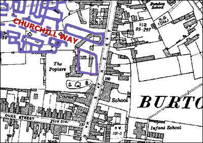
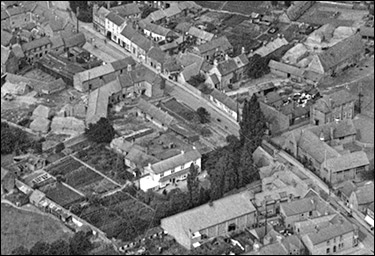
The new plans before Burton Latimer Council for the development of the land between Bridle Road , the Finedon Road Estate, Alexandra Street and Pioneer Avenue promise well for the town’s future.

If you have looked at the Burton town map you will have noticed that development has taken a strange shape – all the houses are grouped on Station Road , Church Street and Cranford Road and the Finedon Road Estate, with a large gap between these sites.

The new plan will make the town a compact unit.  Apparently development of this area has had to wait until the sewerage scheme between Bridle Road and Finedon Road was drawn up, because of the slope of the land

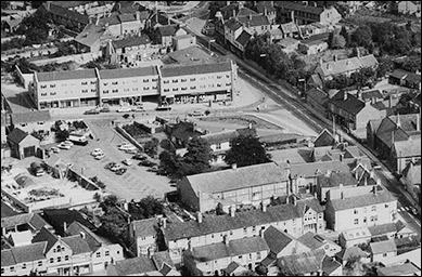
Now that the tenders for the sewerage scheme have been accepted and work is to start in the near future the Council has gone ahead with its plans, and accepted Mr. Edgar Denton ’s application for development of some of his farm land.

Allotment Association land and two fields belonging to the Council are also included in the development area.
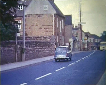
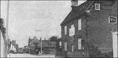
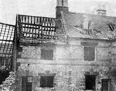
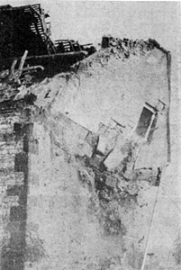
Mr. Denton , whose farmhouse and buildings front on to High Street, first submitted an application for development of 42 acres of farmland excluding his farmhouse and buildings.  But because an access road to the new estate would be required he has agreed to let these go, and the new plan proves for a road  entering High Street where the farm building now stand.

The new estate will, therefore, be connected with High Street, Station Road , Finedon Road and Alexandra Street .

It is a pity that these buildings have to give way to progress, for they are among the Burton Latimer buildings listed for possible preservation.


An overlay of the 1928 Ordnance Survey map, showing how the building of the Churchill Way development in the mid-late 1960s replaced the buildings, yards, paddocks, orchards and fields of the former Denton's Farm.

Aerila view of the central area of the High Street, taken in 1923.  The sachool, the cinema, The Poplars, and Denton's Farm are all clearly distinguishable
An aerial view of the central area in 1971.  The cinema is clearly visible, but the new Churchill Way development has replaced the old farm, and the gardens of The Poplars are now a car park.
Left - An aerial view from 1923, showing Denton's Farm in the upper left-hand area
Right - a similar view from 1971

To view a movie clip of this section of the High Street in the early 1960s, use one of the links below. To view it correctly, you may need to download the Quicktime Player if you don't have it installed. If you have a dialup connection, the movie may take a little while to download.

The clip shows the High Street outside Denton's Farm and also a brief shot of the war memorial when it was moved to the green in front of the Council Offices


Movie clip kindly loaned by Carol Desborough

The end of an era - the demolition of Denton's Farm in 1967

To read more about the Denton Family, click here.


Click here to return to the Main Index
Click here to return to the History & Development Index