|
|||||||||||||||||||||||||||||||||||||||||||||||||||||||||||||||||||||||||
|
|||||||||||||||||||||||||||||||||||||||||||||||||||||||||||||||||||||||||
Researched and presented by Margaret Craddock |
|||||||||||||||||||||||||||||||||||||||||||||||||||||||||||||||||||||||||
 |
|||||||||||||||||||||||||||||||||||||||||||||||||||||||||||||||||||||||||
|
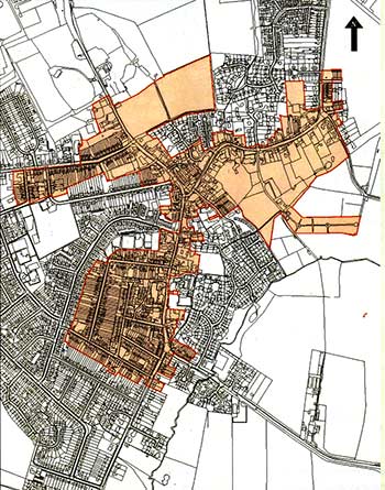
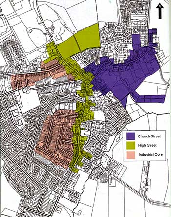
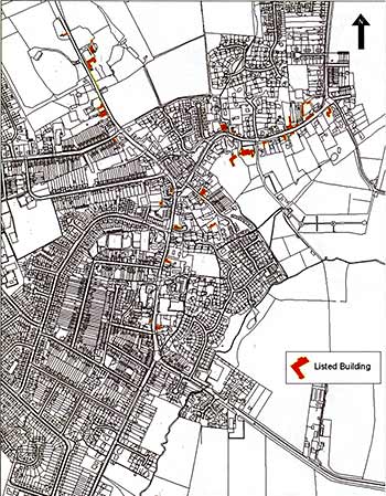
1981 Conservation Area A Conservation Area in the town was established on the 18 March 1981 as a result of a recommendation to Kettering Borough Council by the members of the Burton Latimer Town Council. Mr Douglas Ashby, a member of the town council, provided information on the suggested area to be designated for conservation – mainly the Church Street area and its environments. The buildings to be included referred to the whole of Church Street and the following numbers in High Street: 27, 29, 32, 44, 93, 111, 149 and 172. In addition it was suggested that The Laurels in Church Street, the Round House in Thrapston Road, 1 Meeting Lane, Fernbank in Church Lane, The Limes in Meeting Lane, 14 Meeting Lane, Hall Cottage in Kettering Road and the (then) Council Offices in High Street should be considered. 2009 Conservation Area Rapid growth has taken place in recent years and developers see Burton Latimer as an attractive location to invest. In view of this an extension to the original area was investigated and adopted on 24 November 2009 to ensure that future development is of a high quality and appropriate in its context. The Conservation Area now has three distinct parts comprising Church Street, The High Street and The Industrial Core.
CHURCH STREET A significant feature of this area is the amount of existing open space and agricultural land close to the original core. Land to the rear of the Manor House and the Church together with the cemetery give a very attractive rural character to this area. Some exceptions to these characteristic buildings include 13-23 Woodcock Street and 43-53 Meeting Lane all of which are groups of brick terraces relating to the Industrial Core rather than the typical Church Street properties. As there were so few of these terraces in the area it confirms that the late 19th and early 20th century growth took place to the west of the High Street. General Condition HIGH STREET The High Street retains a number of buildings which positively contribute to the character of the area. The High Street became a turnpike road in the 18th century and formed part of the London to Carlisle Road. It later became the A6 trunk road. There is a mix of building styles and no single dominant architectural style. The location of Burton Latimer along an important communication link has shaped both the town and the High Street. In the past, the road was much narrower and the building line would mostly have followed the edge of the highway. Progress has changed this but in comparison to many modern High Streets, the tight urban form is still in evidence. General Condition The High Street has experienced the most change of all three character areas. Highway improvements during the 20th century led to the widening of the main road through the town. Certain buildings were removed in order to facilitate this, eg ‘Rock Terrace’ which dated from 1881. This terrace stood on the corner of what is now Pioneer Avenue and the High Street and these houses were some of the first properties in Burton Latimer to be built of brick as opposed to stone. The changing face of the High Street illustrates the combination of traditional and modern development. Any proposed development needs to take account of local historic traditions and incorporate suitably high quality materials, learning lessons from the past. INDUSTRIAL CORE The Industrial Core This area has been included in view of the historical significance in the town’s development. It is defined as the area to the west of the High Street and along Station Road. Residential properties in this area are typical red-brick Victorian terraces. Factories manufacturing boots, shoes and clothing were situated between these houses. Some of these factories have now been converted to residential use. The supply of locally available labour for the factories influenced the need for workers’ houses to be interspersed in close proximity to the factories. With the arrival of the railway and the rapid growth of the shoe and clothing industries the town expanded in this manner with a formal, grid-like street pattern eg Duke Street, Alexandra Street, Spencer Street and Finedon Street. These houses were built on narrow plots with long, linear rear gardens. General Condition In the Industrial Core west of the High Street, the buildings are in a good state of repair, but unfortunately the traditional details have been lost on many properties eg the wooden frames and doors and slate roofs. Some additions detract from the traditional rhythm of the terraces. Parking problems are evident in this area due to the terraced streets. INTERRELATIONSHIP OF SPACES Church Street There are two distinct special areas here. The historic agricultural layout and spaces are characterised by relatively dense development abutting the highway. The gaps between the properties are sometimes no more than the width of a farm gate. The area to the east of St Mary’s Church shows this characteristic. The more recent infill developments tend to be standalone dwellings set back in large, regular plots. High Street Approaching the High Street there is a greater density of building. There are fewer gaps between buildings and fewer trees in the High Street than in and aroundChurch Street. Because this area is affected by the commercial and transport requirements, the character has been affected more by development pressures. Stone buildings are no longer apparent nor are those abutting the highway. There is less evidence of open spaces and the surrounding countryside is lost. Although road widening schemes have seen the removal of buildings fronting the High Street, the narrow carriageway is retained with a continuous street frontage at the northern end. Industrial Core The majority of the development throughout the 19th and early 20th centuries took place to the west of the High Street due to the rapidly expanding shoe and clothing industries. The factories were built on vacant plots resulting in Victorian terraces and tightly-packed grid-patterned streets appearing to support the workforce. The properties in these streets, eg Alexandra Street, Duke Street and Finedon Street, were constructed of red brick giving a uniform appearance. FORMER USES AND THEIR INFLUENCE Church Street
This street is the only area of the town where the agricultural character remains predominant although some of the current residential buildings were previously used as agricultural buildings. The existing residential properties were traditionally used as farmhouses with farm workers' dwellings with agricultural land at the rear. The houses in Church View to the north of Church Street have been constructed on the site of the old Rectory and although mature trees have been retained, the traditional vernacular of the surrounding area is not apparent, and therefore, it is not included in the Conservation Area. The area to the south contains St Mary’s Church, the graveyard and the town cemetery. The rural, leafy character of the area is enhanced by the more mature trees located there.
High Street
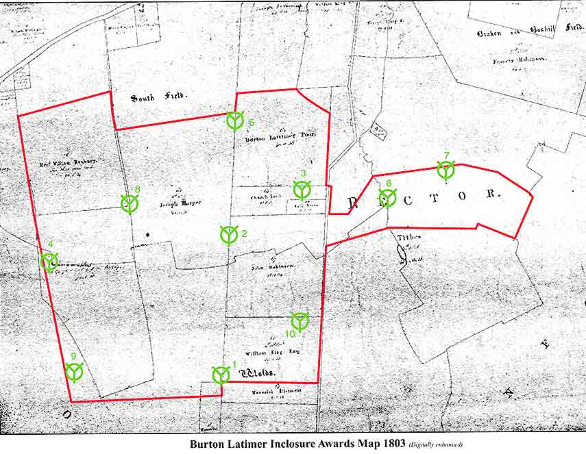
As seen on the 1803 Enclosure Map a clear linear form of building developed along this former stage-coach route. Some of the buildings shown were still farmhouses but the dense layout of these buildings suggests that they were used for retail purposes. The Red Cow Inn 35-37 High Street was a coaching inn, later converted in 1956 to two separate retail units and now demolished for modern development.
Industrial Core In view of the rapid growth of both the boot and shoe and clothing industries in the 19th and early 20th centuries, the industrial core is included in the Conservation Area. Workers' houses were constructed close to the factories following the Victorian street pattern. These narrow streets with their red-brick terraced houses remain although many factories have since been demolished. Some factories still exist and have been converted to residential use and the original sites of those demolished are still evident. VIEWS AND VISTAS
Church Street
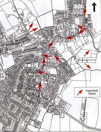
The predominant views are those towards the spire of St Mary’s Church. The spire is visible from most of the Conservation Area and is indicative of the heart of Burton Latimer. The area along Church Street eastwards from the war memorial and westwards from the junction of Cranford Road and Wold Road offer the best views of the church spire. Any location within the cemetery looking towards the spire gives an attractive view. High Street
There are key vistas along the High Street, an important one being that looking from and towards the War Memorial. Views from Kettering Road eastwards extend to open space showing the relationship of the town to the countryside. Industrial Core Although not looking towards open countryside, the traditional buildings in these streets delineate and frame the vistas of the area. (See map p 28) GREEN SPACES
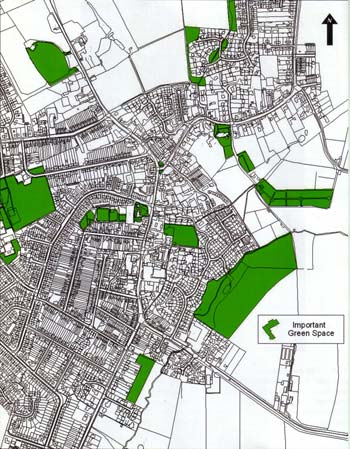
Trees make an important contribution to the character of historic Burton Latimer. There are significant mature trees surrounding the Church, the Manor House and in the gaps between houses in Church Street. An impressive beech tree is situated in front of 90 High Street. There are numerous mature trees in the cemetery and impressive views out towards open countryside. The open areas between houses and other smaller incidental spaces such as highway verges are valuable resources and should be protected from inappropriate development. LOCAL DETAILS There are two distinct groups of traditional materials used within the Conservation Area. Those properties in and around Church Street typically have ironstone, limestone or coursed rubble stone walls and thatched roofs although many of these have been replaced with modern roofing materials. The Industrial Core area differs in that red bricks and roofs of Welsh slate are used. The properties in both areas traditionally had wooden window frames but in some instances in the industrial core, modern materials replace the traditional. The High Street has no single identity as both groups of materials can be seen along with more modern materials. Many of the buildings within the Conservation Area are fairly modest and do not tend to have ornate features. The materials within the construction identify the properties' local character together with the simple elegance of their design. Several buildings around Church Street have date stones and in the Industrial Core the date stones have been placed in between small rows of terraces, showing their year of construction and the name of the group of terraces. Stone boundary walls are a characteristic of the town. There are stone boundary walls along Church Street and the High Street and it is typical in Burton Latimer for these walls to have been constructed at the edge of a highway. There is a mix of low stone walls (one metre high) and high stone walls (approximately two metres high). The quality of the material used adds to the character of the area. Groups of terraced properties in Duke Street, Alexandra Street and Spencer Street have detailing specific to each group, such as a decorative string course (eg 6, 8 and 10 Alexandra Street) and original bay windows such as the pavilion style lead-roofed bays at 11 and 13 Alexandra Street. There are examples of traditional street signs at Duke Street and Alexandra Street and name stones can be found identifying the row of terraces and giving the date when constructed. THE QUALITIES OF INDIVIDUAL BUILDINGS
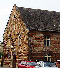
44-48 Alexandra Street On the west side of Alexandra Street stands a modest two storey building at the rear of a small house. It was built as a clothing factory but subsequently became a shoe factory and dates back to approximately 1892.
This building is St Mary’s Old School House, a stone built Victorian school now converted into a residential dwelling. The majority of these schools were built of brick, whereas this particular school follows the same Victorian design principles but is built from materials more typical of Burton Latimer. The direct street frontage appears quite modest, retaining its original window openings with modern timber windows along the ground floor and first floor modern dormers directly above. The bulk of the building is to the rear and is only visible, although prominent given its scale and elevated position, when viewed from the west. Manor House, l Church Street(Grade II listed)
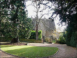
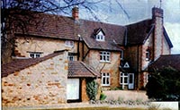
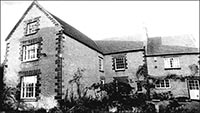
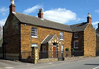
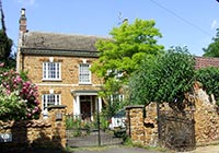
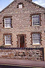
The Manor House is set back from Church Street with trees partially screening the views of the property. The tall two storey house is dated 1704 and has been enlarged and altered during the 20th century. It is constructed of coursed limestone rubble with ironstone decoration. It has a steeply-pitched thatched roof with coped gables and two stone chimney stacks that sit on the ridge. The central projecting wing was added in the 1920s. Most of the windows have wooden lintels and one first floor window retains leaded panes. The mature trees, visible from Church Street, make a more significant contribution to the Conservation Area than the property itself. Manor Lodge, 12 Church Street This is a turn of the 20th century lodge to the Manor House and possibly replaces an earlier building. It appears to be influenced by the Arts and Crafts movement of the same period with its rendered first floor, barge boards and string course detail. Church of St Mary the Virgin (Grade I listed) The parish church is of 12th century Norman origin. Alterations, improvements and restorations have taken place over the years. In the 13th century it was enlarged and a tower was added. In the 15th century a porch was added and the tower and spire were rebuilt. The church is another coursed limestone rubble building but it is obviously strikingly different to the residential properties in the vicinity and far more impressive when viewed from every direction. The church, together with the Manor House, forms the heart of the Church Street character area. The limestone walls have some decorative ironstone banding. There is a steeply-pitched 19th century graduated stone slate roof to the chancel, but the other roofs are concealed by parapets and are not visible. The spire is the most prominent feature within the Conservation Area and is visible from the countryside around. It was a way finder to indicate the position of the Church within the wider landscape as well as being an easily recognisable symbol identifying the use of the building. The low churchyard stone wall is an important feature in this location enclosing the graveyard and the Church.
This is a substantial family house of character and was originally a three-storey 17th century farmhouse. It is situated in Church Lane to the east of St Mary’s Church. Extensive alterations took place in the late 19th century and a front entrance with crenellations was added more recently. The grounds extend to about 2 acres and are a particular feature of this property. The main contribution made to the surrounding area is a one metre high stone wall that forms part of the boundary leading towards the cemetery. This late 17th or early 18th century two-storey house was built of a combination of coursed limestone and ironstone. It has a 20th century tiled roof that replaced the original thatch. Each gable end has a brick chimney. The eaves line has been raised and each gable end has the original parapet with coping stones supported by shaped kneelers (shaped stone blocks). This has been overlaid by the current roof. The ground floor shop window is now blocked off and the entrance is on the right gable end, rather than the street. There is a smaller addition to the left-hand gable. The property abuts the highway and there is a stone boundary wall on two sides of the property. 24 Church Street (Grade II listed)
This early 18th century dwelling was constructed of coursed squared limestone with ironstone dressings to front and coursed limestone rubble to rear. It has a steeply-pitched slate roof that was originally thatched, with two brick chimneys. It is a two storey building with an attic and the gable end facing the street. This property has raised quoins and decorative ironstone banding, ironstone window surrounds with over-sized keystone detail. Although there is a shaped stone panel in the gable – possibly a date stone – the date is now illegible. The ground floor has four casement windows with keystones above whereas the first floor has two windows. There is an early 20th century dormer in the rear slope of the roof and a small modern yellow brick addition to the right of the property 26 Church Street (Grade II listed) This is an 18th century two-storey cottage constructed of coursed limestone and ironstone rubble with a 20th century interlocking tile roof. All openings are supported by timber lintels. It is located to the rear of No.24 . 30 Church Street (Grade II listed) This is an early 18th century house with attached outbuilding built of coursed limestone rubble with ironstone details. The Welsh slate roof (with heightened eaves) would have originally been thatched. It is a typical Northamptonshire two-storey building, which is long and low with quoins and first floor banding. It has moulded brick eaves, coped gables and shaped kneelers. The chimneys are stone and are probably not original. The door and its position is a 20th century alteration – the original blocked doorway is to the right. As with house No.26, all the openings have timber lintels. The outbuilding to the right is now a garage and it is earlier in origin than the house featuring a date stone with the inscription BH/1729. Olde Victoria Public House This public house was formerly known as the Horse and Groom. It is of limestone construction with ironstone detail. There are two bay windows on the ground floor and the first floor windows appear historic. It has a small single storey extension to the east and there is a beer garden to the rear. The building represents one of the last remaining structures along Bakehouse Lane that is true to the original street pattern.
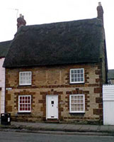
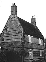
This property has been a post office, butchery and shop at various times throughout history. It has an elevated position within the street scene. There is still a post box at the front of the property which is encased in the attractive stone wall. This boundary wall still retains the traditional stone steps that lead up to the entrance. The property is constructed with limestone on the ground floor and ironstone on the first floor. It now has a 20th century roof and windows following alterations. 51 Church Street (Grade II listed) This former school building, known as the "Jacobean House", is one of the few remaining examples of a thatched roof property in the town although it was originally of tiles. It is said to be one of the oldest buildings in Burton Latimer. The most notable feature is a shaped ashlar gable with finials and inscription above the front door. The building was converted to a house in 1972 following its use as a school in various guises. It was constructed in 1622 and underwent numerous alterations in the 19th century. Its position, set back from the highway, is caused by the camber at this part of Church Street. 60 Church Street (Grade II listed)
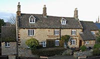
This property is known as ‘The Laurels’ and was originally a farmhouse. It was remodelled in the early 19th century. The construction is of coursed limestone rubble with ironstone decoration. The thatched roof has been replaced with concrete tiles. There are three chimneys one of stone, which may be original, and the other two of brick, probably from the 19th century. It is a three storey, high status building with an eaves dormer and adjacent gable. 61 Church Street (Grade II listed) This house is dated 1859 and is constructed from limestone rubble with ashlar dressings and a slate roof. It is a one and a half storey building. The 19th century detail of the eaves dormers is of particular note. It is part of a particularly important group of buildings together with the “Jacobean House”. 63 and 65 Church Street (65 is Grade II listed) No 63 appears to be a 19th century cottage and is of limestone construction with ironstone banding but does not reflect the traditional vernacular of the town. It has a steep roof with bargeboards and eaves dormer, echoing number 61. No 65 is a 17th century cottage that has been altered. It is built of limestone rubble with ironstone quoins and some rough ironstone banding. The roof was probably changed from thatch to Welsh slate in the 19th century. It is likely that, at this time, the eaves were raised and the building became two storey, rather than one and a half storeys. 67-71 Church Street This is a group of three stone cottages but unfortunately some of the historic detailing has been removed eg the replacement of the original windows and doors with modern uPVC versions. The three properties are double-fronted which sets them apart from the other terraces, which are the more traditional two-up two-down. 73 Church Street (Grade II listed)
Named Beech House, this property is either a late 18th or early 19th century dwelling. It is constructed of ironstone with some limestone decoration to the door surround. It has a large gable to the east which abuts the highway. The principal range is set back from the highway behind a set of iron railings, indicating that this was once a building of higher status. The windows are traditional eight-pane timber sash windows. 79 Church Street (Grade II listed) This was an 18th century two storey house but a third storey was added in the 19th century together with the fitting of new windows. The building is constructed from coursed limestone rubble (with ironstone banding to the original two storeys) and a slate roof. All six casement windows on the principle elevation are beneath timber lintels. Burton Latimer Methodist Church, Duke Street A particular feature of the building is that it still retains the original crittal windows. It is a typical single-roomed Methodist chapel constructed in red brick with a slate roof in 1899. It appears to be contemporary with the surrounding terraces and was built to serve the new influx of workers required by the shoe and clothing industries. 31 Duke Street This is Westfield House and dates back to 1899. It is a higher status building than the surrounding terraced properties and has retained its original wooden sash windows. The external decoration of the property is derived from the use of permanent polychromy by way of ironstone banding within the limestone construction and the use of ironstone in the quoin detail.
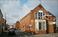
17 and 19 Finedon Road This is a police station in the centre with two residential properties either side. It is a typical early 20th century municipal building. The lower central gable was the police station and is flanked by two two-storey gables which were the police houses. All windows and doors have been replaced and the original door to the police station has also been replaced by a window. These properties are known as ‘Caroline Terrace’ and were constructed in the 1800’s. This terrace is a row of stone cottages on the west side between the corners ofFinedon Street and Rosebery Street. As they are made of stone they differ from the more typical red brick associated with this period of development. Inappropriate replacement modern windows have led to the uniform character being lost. 26 High Street Last used as a Chinese restaurant, this building is thought to have been used as a factory for Wards Clothing Company. It is one of the few former factories constructed of stone and not of red brick. The left-hand side of the building has three ornate arches and, although not easily visible from the High Street, they are definitely a feature of the building.
27 High Street
Although not built of ironstone, Osborne House was named after an ironstone contractor in the town. It still retains the original windows and Welsh slate roof. It forms the left-hand side of the gateway to Church Street. The building has three very distinct parts and appears to have been separate dwellings in the past. The striking bay windows are a 20th century addition.
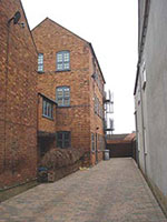
This a long, detached stone house to the north of 31-33 High Street. It is a limestone building with 20th century additions eg modern roof tile, chimney and windows. There is a keystone details on the ground floor lintels. The property is unusual as it is set back from the building line and does not abut the highway. The rear of 29 High Street This is a two-storey L-plan factory attached to the rear of number 29 and was built before 1884. It is currently vacant. David James built the factory on the High Street for the manufacture of clothing circa 1874 and it was later used by Wallis & Linnell for the same purpose c1885 to c1930. The building is of red brick but there are stone panels remaining on the ground floor, suggesting that there may have been an earlier building on the site. It retains its first floor projecting external access.
Named "Dolittle", this house was constructed in the mid 18th century and is particularly striking due to its orientation and surviving thatched roof. It has walls constructed of coursed limestone rubble with ironstone banding. The ironstone detail, including quoins and window surrounds, is of particular merit. 31-33 High Street Now known as the Kushboo Restaurant, this is one of the more notable and high status buildings on the High Street. It was built for David James in about 1899 and became known as Pagoda House. It was actually two shops with the doors in the centre and living accommodation at the rear. This Victorian property is Jacobean influenced with a tower and ornamental gable. The red brick and three-storey construction is a visible landmark on the High Street. The red brick extension to the rear has a particularly fine brick door case.
44 High Street (Grade II listed) This dwelling was probably constructed in the late 18th century but has had later alterations. It is set well back from the highway indicating its higher status compared to the surrounding agricultural buildings. A further indication of this is the coursed ironstone rubble construction with no use of limestone, except for the string course. The ironstone lintels are a particularly attractive detail of this property.
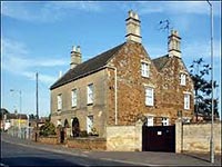
90 High Street This building was once the residence of Frederick Walter Preston, an important figure in the town from the 1870’s until his death in 1913. The external appearance is characterised by white painted stone walls to the principal elevation, with limestone and ironstone visible in the secondary elevations. It was originally a modest cottage and was remodelled in the late 19th century. The modern sash windows are a valiant attempt to replicate the original timber sash windows.
Known as Hilly Farmhouse, this building was probably erected in the early 18th century but with later additions to the left and right. It is constructed in coursed limestone rubble with ironstone bands and the Collyweston slate roof is of particular note. The Farmhouse stands in its own grounds rather than abutting the highway. The view from the street is constricted by a two metre high boundary wall (an important feature in this part of the Conservation Area.) 90a (etc) High Street These two stone buildings are notable for the quality of the stone work and the way in which they reinforce the character of historic Burton Latimer. The buildings are constructed of limestone with ironstone banding. As there are few windows in the High Street elevation the building has a lower status than the surrounding buildings, its appearance probably more agricultural than many along the High Street. 94 High Street
Barclays Bank was built in 1897 as a coffee house as an alternative meeting place to the working men’s clubs. This building had accommodated a Liberal Club between 1905-15 and by 1918 it was known as the Palace Café. It became a branch of Barclays Bank in the 1920s. Later from about 1959 to 1975 the premises were shared with the Post Office. Since 2007 the whole building returned to Barclays. It is a rare example of the Arts and Crafts influence in the town with its tile hanging and rendered ground floor. 96 High Street These premises housed the Electric Palace cinema when built in c1914 by shoe manufacturers, Joseph Westley and Henry Whitney who, together with plumbing engineer A G Miller and others, formed a company. The cinema was bought by Alfred Watts in 1924. Later it was owned by his family until it closed in the early 1960s. The Electric Palace has since been unsuccessfully reopened twice. The impressive entrance arch on the High Street remains although the original building is now accessed from the gardens on High Street. It has now been converted into a restaurant with a modern front elevation but does not retain many of the original features. St Mary’s School, High Street This building dates from the turn of the 20th century and consists of a double-gabled building with a link wing. It is constructed from red brick and slate which gives it an architectural relationship with the industrial core. 111 High Street (Grade II listed) To this 18th century farmhouse, a shop front was added in the 19th century. This is an important feature that details the commercial history and significance of this locality within the Conservation Area. The external walls were constructed of limestone rubble with ironstone bands (street elevation painted). The existing slate roof was built directly over a thatched roof, remnants of which can still be seen in the roof space. It is planned to replace the uPVC insert windows with more sensitive timber casements. The gable end has a date stone but this is no longer legible. 117 High Street In 1903 a house and shop was erected on this site and became the post office for the next 50 years. As well as the post office, it was a newsagents, stationers and lending library. This building illustrates a traditional shop front although it is not the original. The most recent use of this property was as ‘Grandad’s Toys’ – a retail premises with a small workshop and store for handmade toys. The shop is now closed. The red brick construction of this property has an architectural relationship with the industrial core, highlighting the phased development of the High Street. 149 High Street
An old stone house situated between the Band Club and Sainsbury’s bears the date stone ‘A.A.1833’. It was built as the first Wesleyan Chapel in the town – A.A. being the initials for Abraham Ambler, one of the residents of Burton Latimer. The building was converted into a residential dwelling and the dwindling congregation met elsewhere until it recovered and the present chapel was built in Duke Street in 1890.
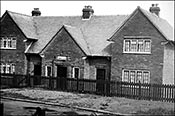
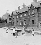
163-165 High Street 'The New Cottage Homes’ were constructed in 1900 as a semi-detached pair of houses replacing the old ‘Cottage Home’ at 159 High Street to the north of this site. The original brickwork and Rosemary roof tiles and all of the windows have been replaced with poor modern equivalents. Initially, only one of the ‘New Homes’ was used, probably No 163 being the nearest to the old building. It was 1915 before an internal doorway was made to connect the two new houses. The New Homes were for the girls whilst the boys occupied the Old Home. In 1919, in view of the declining numbers of children, only the New Homes were continued in use and closed in 1921.
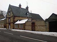
2 Kettering Road This property used to be a shop. It is now referred to as Bakehouse Cottage and is built in Northamptonshire stone. It holds a prominent position at the entrance to Bakehouse Lane. This property next door to 2 Kettering Road is probably the best example of a stone building that until recently retained its original wooden shop front. It is a good example of just how important the historic turnpike has been in the development of both the High Street and Burton Latimer.
This property is referred to as ‘Spring Gardens Barn’ and includes an impressive stone archway that is very prominent and important to the character of this part of Kettering Road. In addition, there is a stone barn with ironstone banding and a significant gable facing the highway. 24 Kettering Road – The Wagon and Horses
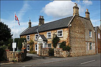
This building was one of the coaching inns so crucial in the town’s development. It has London Stock brick window detailing, ironstone banding, original wooden windows and has probably been shortened at some time. Since 2010 it has become a private home. 73 Kettering Road (Grade II listed) – The Yews A mid 18th century property, now a residential home, constructed from coursed rubble with ironstone bands and a slate roof. The double gable, one of which is rendered, fronts Kettering Road, with the principle elevation only visible in glimpses when approached from the south. It is probable that the 20th century windows have replaced the original casement windows. The gateway to the property is an important feature in the street scene and is also an indicator of the status of this property.
75 Kettering Road (Grade II listed) This farmhouse has a gable end facing the street, as the previous property at number 73. It was constructed in the 17th century as two separate buildings, linked and altered in the late 18th century. It is built of the locally characteristic limestone, with ironstone detailing, a slate roof and coped gables. The first floor windows have wooden lintels and the rest are ironstone. A fine stable block lies opposite to the house. 9 Station Road (Grade II listed) This is a 17th century property that has been extensively altered but is an interesting survival from this period. It appears to have been a group of farm buildings in the past, reflecting this area’s historic agricultural links prior to the 19th century industrialisation. The property itself is typical of the Northamptonshire vernacular from the period, although it appears to have lost many of its original features.
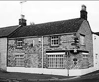
1 Meeting Lane – The Thatchers
This property was originally built in the 1800’s as The Thatcher’s Arms but has been a private residence since 1957. Originally there was an adjoining building on to
BaptistChurch,Meeting Lane(Grade II listed) This building was constructed in 1744 and has a Collyweston stone slate roof. The gable end to the street is characteristic of this building type, but also reflects the character found along Church Street. The building is visually striking as it is constructed from ironstone, rather than it being used purely for decorative purposes. There are two inbuilt boot scrapers to the front of the building which are an interesting feature. The adjacent meeting room is also of note, including its large timber windows. Together with 23 Meeting Lane, this Baptist Church forms an important group.
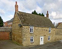
14 Meeting Lane (Grade II listed) – Nutcracker Cottage This property dates from the 17th century. It is constructed from semi-coursed rubble stone which is now painted. The 20th century concrete interlocking tile roof has replaced the original thatch. It has two low storeys and retains its historic board door and three-light window in the stone and brick lean-to addition to the left. It also retains the canted bay window with small-paned casement openings and small single-light window with wooden lintel above. To the right of the ground floor is a three-light casement window with wooden lintel.
This is a painted brick building pre-dating 1893. It is an interesting end-terrace, as the gable end has become the principal elevation. Architecturally it appears to be associated with the adjacent Baptist Church and meeting rooms. There is an illegible plaque on the front gable which has been painted over. The original windows are retained. The Workshop, Meeting Lane
Because of its location behind a modern brick building and its position adjacent to a mid-20th century industrial unit, this building is easily overlooked. It is of stone construction and the north-west stone elevation is the more prominent when viewed from the Conservation Area. The two-storey south-east elevation, with its rendered stone and original windows, should not be dismissed. It appears to have single-storey storage units added to this elevation but the original form of the building is retained behind the addition. GENERAL CONDITION OF THE CONSERVATION AREA NOTE: All maps reproduced from Ordnance Survey mapping. Material taken from the Kettering Borough Council Appraisal booklet for Burton Latimer Conservation Area. In some instances factual errors have been corrected to ensure accuracy. |
|||||||||||||||||||||||||||||||||||||||||||||||||||||||||||||||||||||||||
|