|
||||||||||||||||||
|
||||||||||||||||||
|
||||||||||||||||||
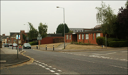
| As the High Street rises steadily from the junction with Newman Street towards the corner of Pigotts Lane, it currently passes the Library and the former Health Centre. The pathway on the west side of the street is distinctly higher than that on the east side, and always has been. This is a result of the general lie of the land, which has set the pattern for all the development on the west side. On the east side, the land falls away down to the brook which runs under the bottom of Higham Road; on the west side the land rises gently up towards the area now occupied by the Recreation Ground. Coles Close is thus at a higher level than the High Street, and Churchill Way is higher than Coles Close.
With the pathway being higher on the west side, there needed to be a special kerb arrangement if the road was to be kept level. The solution for much of the nineteenth and twentieth centuries was to have a double kerb arrangement. This required people crossing the road from the east side to use the first kerb as a step, and led to the pathway being dubbed "The High Causeway" - a nickname which gradually became applied to all the houses lining the path. Officially, this area was still the High Street, but everyone knew where you meant if you mentioned the High Causeway!
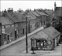
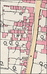
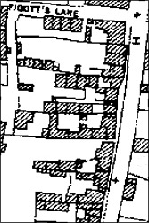
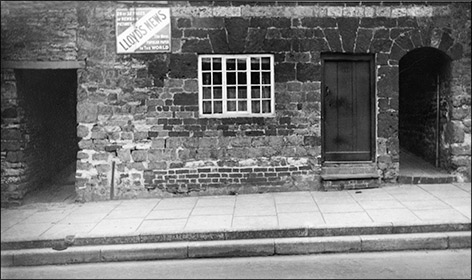
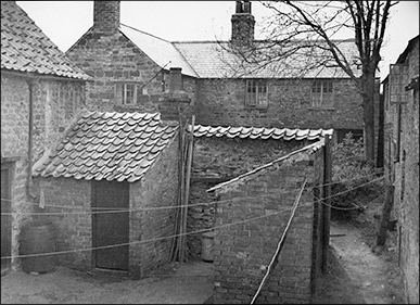
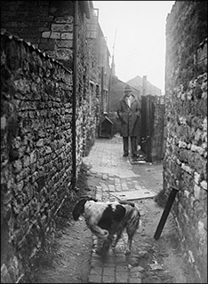
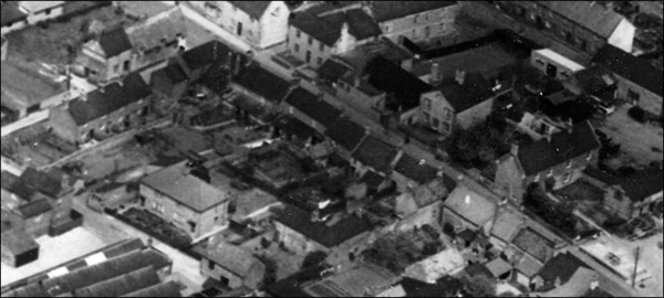
This section of the High Street was characterised by a frontage of stone cottages and two complexes of further cottages round a well or pump. These complexes tend to be called "Yards", and are a common feature of many local small towns and villages. The northern yard seems to have been known originally as Hobbs Yard, and a Mr Hobbs is shown on the 1804 enclosure map as owning land nearby. The southern yard was known as Maycock's Yard. Both names appear in various Census returns for the nineteenth century. The yards were accessed via two alleyways which can be seen on the maps shown here as two narrow parallel sections in the centre of the frontage. There was also a peculiar building line. Instead of the straight frontage one might have expected, there was a concave one, possibly due to the piecemeal nature of the building developments and the orientation of the first properties to appear. The road did not follow the line of the buildings, and as a result the path in the centre of the High Causeway was much wider than the sections above and below it, as can be seen on the maps and also the picture below. |
||||||||||||||||||
|
||||||||||||||||||
|
The Shops
There were two shops in this part of the High Street, on the corner of Pigott's Lane there was a barber's shop. In the early part of the last century it belonged to the Skevingtons, before the Benford family took over. Full details of the businesses can be read here. Lower down the street there was another shop. Originally belonging to the Kilborn family in the early part of the last century, when Mabel Kilborn married Walter Piper (whose family ran the ..... business next door) the shop became known throughout Burton as "Mabel Piper's". It sold mainly sweets and tobacco. Today it is a hairdresser's with a Fitness Centre built on the back. To read more about the shop, click here.
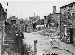
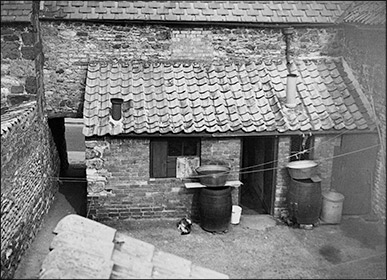
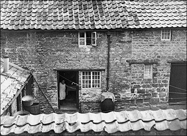
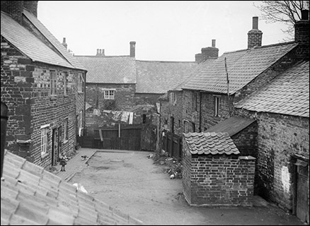
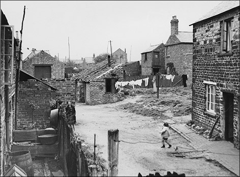
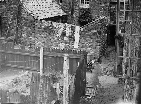
The Yards Though the notion of living in a group of stone cottages around a communal yard might seem nowadays to have a certain picturesque charm, it is easy to forget that the everday reality for the people who inhabited them was somewhat different. We now take so many amenities for granted: like a mains water supply, indoor toilets and damp-proof accommodation - none of which were enjoyed by the tenants of the cottages in the yards. There was little incentive for landlords to improve the accommodation, and only the most basic running repairs tended to be done. Early Ordnance Survey maps (like the 1886 one above) bear the letters W and P to indicate the well or pump which was the only source of water for the properties. Every drop of water had to be fetched from outside - for drinking, washing, cooking and general cleaning. Bathtime usually consisted of hot and cold water being poured into a galvanised (zinc-coated) steel bathtub brought in from the kitchen or outside, and placed in front of the fire in the living room. The bathtub was often so small that people generally had to stand to wash themselves, or sit in it with their knees drawn up high. It was not surprising that by 1935, the Council considered the accommodation unfit for human habitation and was pressuring landlords to improve it, under the threat of enforced closure and demolition. Click here to read of some of the case concerning Miss Talbutt and Wallis' Yard. The demolition of the yards took place in 1938. Fortunately, a set of photos was taken in the final months before the gangs moved in, and they provide an invaluable glimpse into what life must have been like for the tenants - a far cry from anything we would now remotely consider acceptable. Maycock's Yard This was the yard accessed through the southern alleyway. There was a large detached property at the back, but mostly it was a collection of small stone cottages with tiled roofs.
Wallis' Yard Towards the end of the nineteenth century, the shoe industry arrived in Burton. The very beiginnings were characterised by small units - outworkers, small production sites, etc - nowhere near the scale of the factories which were later built to gather the personnel together into a large-scale workforce. In Hobb's Yard - the yard entered via the northern alleyway - a Mr Wallis used a small building for the production of boots and shoes. He later relocated to another address, but the yard seems to have become known as Wallis' Yard, and that name survived until the demolition in 1938.
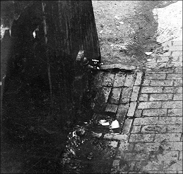
For much of its history, Wallis' Yard had a well to supply its water, as did many other yards. These wells were not the "olde wishing well" type, with a gable cover over a circular brick surround, and a cranked handle lowering a bucket on a chain. Instead, they were open shafts covered by two flat boards, hinged at the sides. The flaps were thrown open, and a bucket with a rope attached to the handle was thrown down and hauled up. The technique was to throw the bucket in upside down, so that it filled with water instead of just floating! Eventually, mains water arrived. However, this did not mean the end of the trek outside to fetch water. All the properties ever had in the way of a pressurised water supply was a single standpipe outside....
|
||||||||||||||||||
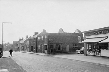
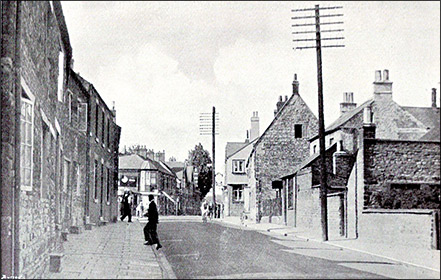
When the yards were demolished, it was the end of an era, but to passers-by out on the High Street, very little had changed - the familiar High Causeway frontage remained for another fifty years.
The End of the High Causeway cottages
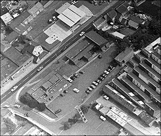
We can also see from the photo that changes were already taking place to the southern section of the High Street. The old farmhouse of Washpit Farm, which had served as the home for the Mason family when they ran the garage which operated on the old farm site, had been demolished and new tarmac covered the forecourt and car sales lot. (Read more about this part of the High Street here). Suddenly, the east side looked very open. Changes were coming to the west side too. Close inspection of the photo shows that some of the properties were already boarded up. With the steady growth of the town, some key services were becoming inadequate, and a decision was taken to demolish the High Causeway cottages and to build a new Library and a Health Centre on the cleared site. The process began in 1969. Strangely, it was the two brick-fronted cottages which were demolishde first, followed by others at the top end of the High causeway. Gradually, the whole site was cleared.
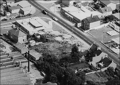
The overall effect of the redevelopments can be tracked by looking at the two aerial views presented below. The first view is from the south-west, taken in 1971. The Health Centre is in place, but the site for the Library is still rough ground. The second view is from the west, taken in 1984. The Library is now there, and the properties behind the Health Centre have been demolished to create a large car park.
A last look back
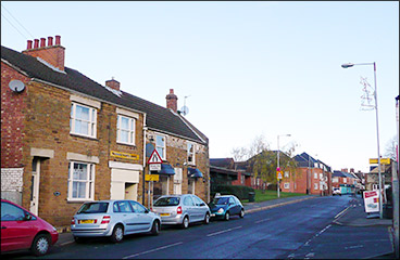
The High Causeway frontage was a familiar section of the High Street for the best part of two hundred years. To those who knew it, it was part of the character of the town. However, time marches on, and communities may expand or contract. Burton Latimer has continued to expand, and such a process brings with it many changes. We may regret the loss of familiar sights, and those who knew the High Causeway or walked up and down it whenever they went to town may still see in their mind's eye the view in the image above on the left. How many people queuing to take out or return a book at the desk in the Library would know that once, not very far from the spot, people might similarly have queued to get water from a standpipe or a well? |
||||||||||||||||||
|
||||||||||||||||||
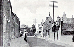
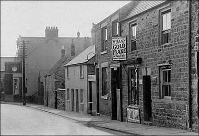

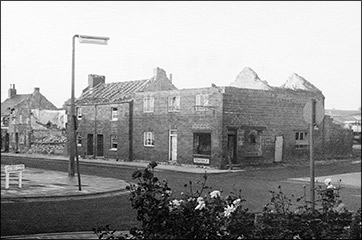
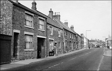
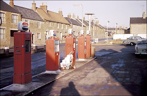 In this rare colour photo of the High Causeway, probably taken in the late 1960s, we can get an idea of the character they had and the impression they created for those passing though this part of the town. The frontage was a mix of limestone and ironstone, but two houses near the far end had a face of red brick.